Saturday, June 18, 2005
GPS and Mapping Software
Wondrous stuff, this technology. I love maps, to explore and plan where we want to go. We have the Rand McNally Road Atlas (large print edition!) and it's almost always on my lap while Jim's driving. It's the best way to see at a glance what's in the area. They have spent years revising and revising again and they've figured out the best way to indicate the most number of features in the smallest, most understandable way.
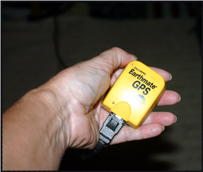
But, the GPS with mapping software is by far the best way to see exactly where you are and how to get to where you're going. The GPS is just this little device that plugs into a USB port in Jim's laptop computer - then you place it on the dashboard, or, in our case up in the cab-over area.
Then you need mapping software on the computer. The most popular software for RVers is Delorme's Street Atlas. We have that but we use another one from Microsoft called Mappoint. Mappoint is intended more for businesses that want to plot data on a map. It is more expensive and really a bit overkill for RVers, but we have it anyway due to Jim's status as a Microsoft Partner. We like Delorme for the speaking capability - it will verbally alert you when you are within a mile of your next turn, for example. But we like Mappoint better for it's built in data. We can query for 'all campgrounds within 10 miles' and we get a lot more results than with Delorme. Plus, being a Microsoft product, the interface is just more familiar to us. Here is what your screen looks like while you're traveling:
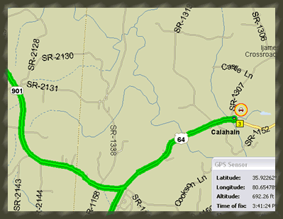
The heavy green line is the route that you've planned. The little car in the red circle is you. It is so cool to watch it as you're traveling. That little car moves along the route, letting you know, every second, exactly where you are. You can zoom out for the big picture of the whole state, or you can zoom in close enough to see city blocks. You can get a comfort feeling just by glancing at the screen and seeing that the little car is following the green line. But, where it is invaluable, is when you get off the green line. In other words, when you're lost, you know exactly where your are!
For example, yesterday, we saw big signs on the Interstate advertising a Winery with tours at exit 100. Hey, we haven't visited a winery in a while, let's go see what North Carolina has to offer! So we got off the highway and made the turn according to the big signs. We're not on the green line anymore! We're on one of those little gray lines - SR 2143 or something. And, we don't see anymore big signs for a winery. If you were just driving a car, this is not a problem. You simply find a driveway, pull in and turn around. But, when you're in a 30 ft motorhome, towing a car, you don't have that option. You need to keep driving forward. The only way to turn around is to find a large open parking lot, and there were none to be had on county road 3937! Because of the GPS and Mappoint, I could see exactly where we were and instructed Jim which little roads to turn on to get us back to the highway - going forward all the way! This has saved our **s many times! I wouldn't travel in a motorhome without it.
But, the GPS with mapping software is by far the best way to see exactly where you are and how to get to where you're going. The GPS is just this little device that plugs into a USB port in Jim's laptop computer - then you place it on the dashboard, or, in our case up in the cab-over area.
Then you need mapping software on the computer. The most popular software for RVers is Delorme's Street Atlas. We have that but we use another one from Microsoft called Mappoint. Mappoint is intended more for businesses that want to plot data on a map. It is more expensive and really a bit overkill for RVers, but we have it anyway due to Jim's status as a Microsoft Partner. We like Delorme for the speaking capability - it will verbally alert you when you are within a mile of your next turn, for example. But we like Mappoint better for it's built in data. We can query for 'all campgrounds within 10 miles' and we get a lot more results than with Delorme. Plus, being a Microsoft product, the interface is just more familiar to us. Here is what your screen looks like while you're traveling:
The heavy green line is the route that you've planned. The little car in the red circle is you. It is so cool to watch it as you're traveling. That little car moves along the route, letting you know, every second, exactly where you are. You can zoom out for the big picture of the whole state, or you can zoom in close enough to see city blocks. You can get a comfort feeling just by glancing at the screen and seeing that the little car is following the green line. But, where it is invaluable, is when you get off the green line. In other words, when you're lost, you know exactly where your are!
For example, yesterday, we saw big signs on the Interstate advertising a Winery with tours at exit 100. Hey, we haven't visited a winery in a while, let's go see what North Carolina has to offer! So we got off the highway and made the turn according to the big signs. We're not on the green line anymore! We're on one of those little gray lines - SR 2143 or something. And, we don't see anymore big signs for a winery. If you were just driving a car, this is not a problem. You simply find a driveway, pull in and turn around. But, when you're in a 30 ft motorhome, towing a car, you don't have that option. You need to keep driving forward. The only way to turn around is to find a large open parking lot, and there were none to be had on county road 3937! Because of the GPS and Mappoint, I could see exactly where we were and instructed Jim which little roads to turn on to get us back to the highway - going forward all the way! This has saved our **s many times! I wouldn't travel in a motorhome without it.
posted by Chris at 6/18/2005 09:13:00 AM
Links to this post:
0 Comments:
links
2 computer geeks and one perfect poodle, live and travel in their RV making a living with computer skills. Computer Education for RVers, Internet Satellite Installations, Wi-Fi help, Website design.
Previous Posts
- Google Earth
- Blog Migration Successful!
- Blogger migration
- Water in the River
- Christmas Day
- It's a Wonderful Life
- Sittin' on the Bench of the Bank
- The Park is filling up
- Solomons Castle
- Visitors
Archive
My links
- Blog Index
- Site Feed
- Map of where we are now
- "Geeks on Tour" Our Business Website
- Our Web-based Photo Albums
- Mom's Blog
- Other RVers
- Diane and Andy's Blog
- Tioga and George
- Brightwing RV
- Lynne and John
- Cliff and Marie
- Hitch Itch: RV Travel Adventures and Journals
- Gypsy John
- Anne and Norm (fellow divers now discovering RVing!)
![]()